

When building a house, sometimes you will need a plan of the site showing the slope and steepness of the building site. This can be done by anyone who has the equipment and knowledge to undertake such a task, but most often, this task is undertaken by a Land Surveyor who specialise in obtaining this information accurately.
The land surveyor uses equipment to take what are called 'levels' across relevant parts of the building site. A 'level' is a spot on the building site where a height is taken to determine the slope of the land and its steepness.
The image below is a Land Surveyors drawing of a building site.
(click image for larger view)
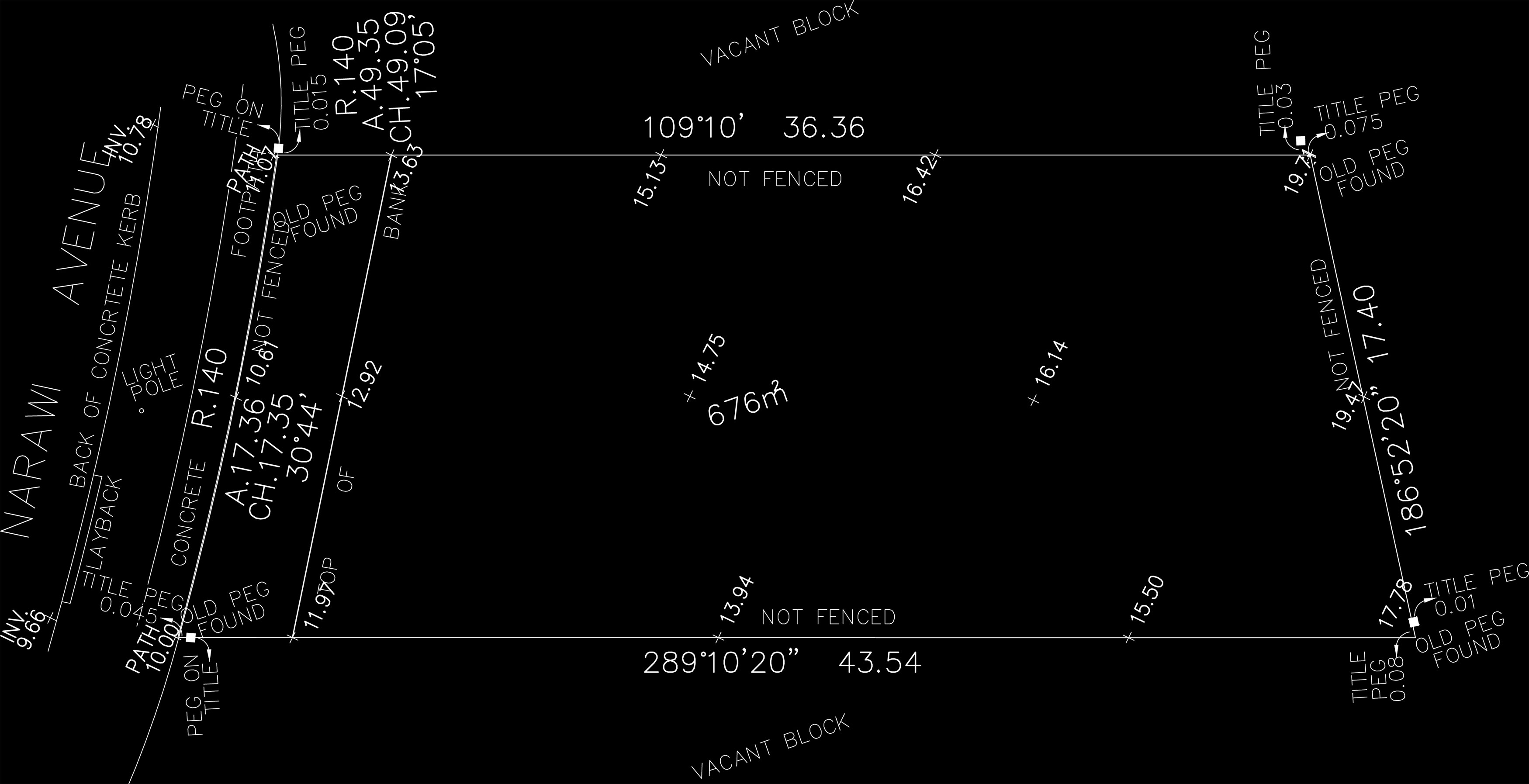
The levels on the site plan are the numbers next to the crosses on the site plan. They look like this:

The heights where these 'levels' are located are referred to as the Reduced Level (or R.L for short)
The R.L can be referenced in 2 ways. As an arbitary number, or, according to the Australian Height Datum (AHD)
If you look at the site plan, on the bottom left of the corner of the site is the level 10.00. That is the lowest point on the site, so lets use that as our reference number to determine the heights of the levels above this reference point.
If we work from left to right along the bottom of the site boundary from the number 10.00, then next number is 11.97. That means at this point, the land is 1.97metres above the bottom left corner of the site.
We work that out by taking 10.00, from 11.97. So the basic maths is (11.97 - 10.00 = 1.97) Note that Land Surveyors drawings equate to metres. So 1.97 is 1.97 metres above the R.L of 10.00
The next number is 13.94. So (13.94 - 10.00 = 3.94) or 3.94 metres above R.L 10.00
Below is a section through the site on the site boundary. (click image for larger view)

The thick line represents the site. I have drawn an imaginary horizontal line from the R.L 10.00. I find this the easiest way to set a reference line for offsetting the heights of the other R.L's above the R.L 10.00 level.
So what we can determine from the site boundary on the bottom of the plan, is that the land is 7.78 metres higher than the R.L 10.00 reference point located on the footpath.
In addition to the information I provide for designing and drafting your own house, I have another side project that tells you how long a house or land has been For Sale or Rent in Australia.
It is also Free to Use and also has a search to give you a price range indication of house and land
for sale that doesn't have a listed price.
It is called Get House Date www.gethousedate.com.au Mobile Friendly too.